Detecting on County Durham
A Guide for Metal Detectorists Exploring the North-East
Chapter One: County Durham
County Durham sits in the heart of the North-East of England, bordered to the north by Tyne and Wear, to the south by North Yorkshire, to the east by the North Sea, and to the west by Cumbria. It is a county of dramatic contrasts — wild moorland and deep river dales in the west, a rich industrial and mining heritage through its centre, and a dramatic Heritage Coast stretching along its eastern edge. For the metal detectorist, this diversity of landscape and history makes County Durham one of the most rewarding counties in England to explore.
The county is home to more than 7,000 recorded sites of archaeological interest noted on the County Sites and Monuments Record database, a staggering figure that hints at just how many layers of human history lie beneath the soil. From prehistoric Bronze Age burial mounds and Iron Age farmsteads, through to Roman forts, medieval settlements, Civil War battlegrounds, and the industrial ruins of a great mining era, County Durham offers the detectorist a genuine journey through time. Every swing of the coil carries the possibility of unearthing something that has not seen the light of day for hundreds, or even thousands, of years.
What makes the county particularly special for our hobby is the sheer variety of periods represented in the ground. In the west, around the Pennine moorlands of Teesdale and Weardale, you are in ancient country — places where Bronze Age and Iron Age peoples farmed, traded, and buried their dead. As you move east, the landscape carries the unmistakable imprint of Rome, with forts, roads, and civilian settlements running from west to east across the county. The medieval period is equally well represented, with the dramatic landscape dominated by Durham Cathedral and Durham Castle — a UNESCO World Heritage Site — while market towns, monastic sites, and deserted medieval villages dot the countryside. And of course, the legacy of coal mining that shaped the 19th and 20th centuries has left its own archaeological signature, though finds from this more recent era tend to be of industrial rather than monetary value.
County Durham is also a county where the metal detecting community has a proud and productive history. The Dunelme Metal Detecting Group, the county’s longest-established club and a member of the National Council for Metal Detecting, has worked closely with Durham County Council’s Archaeology Service to carry out detecting on important sites including the civilian settlement surrounding Binchester Roman Fort. This spirit of cooperation between detectorists and archaeologists has produced genuinely significant discoveries and, importantly, has helped build a positive reputation for the hobby across the region. Whether you are a seasoned detectorist or someone just starting out, County Durham rewards those who approach it with respect, enthusiasm, and a healthy sense of adventure.
The Landscape and Its Detecting Potential
To understand where to detect in County Durham, it helps to think of the county in broad zones. To the west lie the high Pennine dales — Teesdale, Weardale, and their tributary valleys — where the land rises towards the watershed with Cumbria. These upland areas were settled and farmed in prehistoric times, and Bronze Age activity in particular left a significant mark on the landscape in the form of burial cairns, field systems, and ritual sites. The soils here tend to be acidic and heavy, which can affect the preservation of metals, but Roman and medieval finds have been made across these dales, particularly near river crossings, ancient trackways, and former farmsteads.
The central band of the county is where the historic core of Durham lies. The city of Durham itself, set on a great loop of the River Wear, has been continuously occupied since at least the late Anglo-Saxon period. The surrounding farmland and river valleys carry enormous archaeological potential, with Roman roads, medieval field systems, and former monastic lands all waiting to be explored. The village and parish churches of central Durham are often the focal points of communities that stretch back over many centuries, and ploughed arable fields near these ancient centres of population are prime detecting territory — with landowner permission, of course.
To the east, the county opens out towards the coastal plain and the North Sea. This is where the great coalfield once dominated, and the landscape here bears the scars and footprints of heavy industry. But look beneath the industrial legacy, and you find earlier settlement patterns — Viking activity along the coast, medieval fishing communities, and the remains of earlier agricultural economies. The coastline itself, known as the Durham Heritage Coast, runs from Seaham in the north to Crimdon in the south, and offers the beach detectorist some genuinely interesting opportunities, particularly after winter storms have stripped back the sand and exposed older layers of sediment.
Legal Framework and Best Practice
Before you set a single boot on County Durham soil with a detector in hand, it is worth being absolutely clear about the legal framework that governs detecting in this part of England. The rules here are no different from those applying across England and Wales, but the county’s archaeology service has historically taken a particularly active interest in ensuring that detecting is carried out responsibly.
The first and most fundamental rule is that you must have written permission from the landowner before detecting on any piece of ground. This applies whether the land is farmland, woodland, common land, or foreshore. Without that permission, you are potentially liable for trespass, criminal damage, or even theft — so always get it in writing and carry a copy with you in the field. Most farmers and landowners who have had positive experiences with detectorists are happy to give permission, but you need to ask politely, explain clearly what you intend to do, and make a commitment to fill any holes, remove your rubbish, and report any significant finds.
Scheduled ancient monuments are completely off-limits for metal detecting under the Ancient Monuments and Archaeological Areas Act 1979. County Durham has numerous scheduled sites — Roman forts, prehistoric burial mounds, medieval earthworks — and the penalties for detecting on them without authorisation are severe. The Sites and Monuments Record held by Durham County Council is the best reference point for identifying scheduled sites in any area you plan to detect. If in doubt, contact the Archaeology Section at Durham County Council, who are generally very helpful and will advise you on whether a proposed site is protected.
Treasure finds — which include coins more than 300 years old found in groups of ten or more, objects containing at least 10% precious metal and over 300 years old, and any group of prehistoric metallic objects — must be reported to the local coroner within 14 days of discovery. The Portable Antiquities Scheme (PAS) is the voluntary recording framework for all other archaeological finds, and reporting your discoveries to the North-East Finds Liaison Officer is strongly encouraged. Not only does this contribute to the wider body of knowledge about the county’s past, but it also builds the positive relationship between detectorists and archaeologists that benefits everyone in the long run.
The Crown Estate foreshore — the strip of beach between the mean high water mark and the mean low water mark — can be detected without a specific permit, though it is always worth notifying the relevant authority before you go out. The National Trust manages significant stretches of the Durham Heritage Coast and generally does not permit detecting on its land, so check ownership carefully before planning any coastal trip
Chapter Two: Roman Durham — Forts, Roads, and Lost Legions
The Roman Presence in County Durham
Of all the historical periods represented beneath the soil of County Durham, it is arguably the Roman era that offers the metal detectorist the most tantalising possibilities. The Roman military and civilian presence in the county was substantial, lasting from the late 1st century AD through to the early 5th century, and the archaeological legacy of that occupation is spread right across the county in the form of forts, roads, marching camps, civilian settlements, and industrial sites.
The Romans arrived in what is now County Durham as part of their northern campaigns to subdue the Brigantes tribe and establish control over the whole of what they called Britannia. The great military road known as Dere Street — the main Roman route from York northwards through County Durham and into Scotland — runs through the heart of the county, passing through the area around Piercebridge, Binchester, and on northwards. This road was one of the most heavily trafficked routes in Roman Britain, used by legions, supply convoys, merchants, and travellers for three centuries or more, and the land beside it is rich in archaeological potential.
The significance of the Roman connection was dramatically underlined by a remarkable discovery at Piercebridge on the River Tees. Divers exploring the river bed uncovered an extraordinary collection of 3,619 Roman objects, which Durham University archaeologists subsequently studied in detail. The finds revealed fascinating patterns of deposition — objects thrown into the river, perhaps as offerings, perhaps lost during military crossings, or perhaps deposited by the local population as votive offerings to the river gods. The variety of object types, from coins and personal ornaments to military equipment and everyday domestic items, gives a vivid picture of life along the Roman frontier, and points to the enormous range of finds that still lie waiting to be discovered across the county.
Binchester Roman Fort
Binchester — known to the Romans as Vinovia — is perhaps the most important Roman site in County Durham and one of the largest Roman forts in the whole of northern England. Located near Bishop Auckland, it occupied a commanding position above the River Wear and controlled one of the key river crossings on the road north. Occupied from the late 1st century through to at least the early 4th century, Binchester was home to a succession of auxiliary cavalry units, and the civilian settlement — or vicus — that grew up around the fort was a substantial and prosperous community.
The site has been the subject of ongoing archaeological investigation, and the Dunelme Metal Detecting Group has worked alongside professional archaeologists at Binchester as part of a formal project. This collaboration has produced significant results, with the distribution of metal detected finds helping to map the extent of the civilian settlement and reveal previously unknown areas of Roman activity. Coins, brooches, military fittings, and personal ornaments have all been recovered from the wider landscape surrounding the fort, and artefact distributions have been shown to follow the line of the Roman road — a beautiful illustration of how methodical detecting can contribute to archaeological knowledge.
It is vital to note that Binchester Fort itself is a scheduled ancient monument and cannot be detected without formal authorisation as part of an approved archaeological project. However, the surrounding landscape outside the scheduled area, with proper landowner permission, has proven highly productive for detectorists over the years. If you are planning to detect in the vicinity of any known Roman site in the county, always check the scheduled monument boundaries first and ensure you are working in an area that has been formally cleared.
Roman Roads and Marching Camps
Beyond Binchester and Piercebridge, the Roman landscape of County Durham is criss-crossed with roads, marching camps, and smaller installations that have rarely received the detailed attention of professional archaeologists. Dere Street is the most significant of these routes, but there were subsidiary roads linking the main forts to each other and to the wider military network. Areas near these roads — particularly where they cross river valleys, pass through former farmland, or run near known settlements — are always worth investigating.
Roman marching camps, the temporary overnight enclosures used by legions on campaign, are known from several locations across the county, particularly in the upland areas to the west. These sites represent brief moments of military activity, and while the finds potential is generally lower than at permanent fort sites, coins, hobnails from military sandals, and small personal items have all been recovered from marching camp sites elsewhere in northern England.
The coins most likely to be encountered in Roman contexts in County Durham range from the Republican and early Imperial periods through to the late 3rd and 4th century debased coinage of the period of military crisis. Copper alloy as and sestertius coins are the most common, but silver denarii and even gold aurei have been recorded from the county. Brooches — both functional and decorative — are among the most visually striking Roman finds, with the colourful enamelled examples produced in the late 2nd and 3rd centuries being particular favourites among collectors. Military belt fittings, strap ends, and harness mounts also turn up regularly in areas with a strong military association, while household items such as steelyard weights, spoon fragments, and vessel mounts reflect the domestic life of the civilian population.
Tips for Detecting Roman Sites
When detecting in areas with known Roman potential, a systematic approach pays dividends. Rather than sweeping randomly, walk parallel transects across the field, noting the position of all finds on a map or GPS unit. The clustering of finds can reveal the outlines of former buildings, roads, or activity areas that would be invisible to the naked eye. Pay attention to field boundaries, old trackways, and any earthwork features visible in the landscape — these often overlie much earlier features and can guide you towards productive areas.
In terms of equipment, a good quality machine with strong discrimination capability is important for Roman sites, as the ground can contain substantial quantities of ferrous debris from centuries of agricultural activity. A smaller search coil can help in areas with high iron contamination, allowing you to pinpoint individual targets more accurately. Always dig every signal carefully — Roman copper alloy objects are often fragile and heavily corroded, and a carelessly wielded trowel can easily damage something that has survived intact for two thousand years.
Chapter Three: Medieval Durham — Castles, Monasteries, and Market Towns
The Power of the Prince-Bishops
For most of the medieval period, County Durham existed as a unique entity within the English state — the territory of the Prince-Bishops of Durham, who wielded both ecclesiastical and secular power over the county. This arrangement, known as the County Palatine, gave Durham’s bishops extraordinary authority, including the right to raise armies, hold courts, and mint their own coinage. The result was a county with a particularly rich institutional and architectural heritage, dominated by the great cathedral and castle at Durham city but extending outwards through a network of monastic houses, episcopal manors, market towns, and agricultural communities.
Durham Cathedral, begun in 1093 and regarded as one of the finest examples of Romanesque architecture in Europe, was at the centre of a powerful monastic community that owned extensive lands across the county and beyond. The wealth that flowed through the cathedral priory and its network of dependent cells and granges left an archaeological footprint that extends into the surrounding farmland — coins, seals, pilgrim badges, and devotional objects have all been found in areas associated with medieval religious communities across County Durham.
The pilgrim trail to the shrine of Saint Cuthbert at Durham Cathedral was one of the most important in medieval England, and pilgrims travelling from north and south would have passed through the county carrying small objects of devotion, coins for offerings, and personal jewellery that could easily be lost along the route. Pilgrim badges — the small lead or pewter souvenirs sold at shrines and worn on hats or clothing — are among the most sought-after finds for detectorists working medieval routes, and examples associated with the Cuthbert cult have been recorded from sites across the North-East.
Medieval Towns and Villages
Beyond the cathedral city, County Durham was home in the medieval period to a network of market towns, agricultural villages, and isolated farmsteads. Towns such as Bishop Auckland, Barnard Castle, Darlington, Stockton, and Hartlepool all developed their own distinctive characters during the medieval centuries, serving as centres for trade, administration, and local industry. The ploughed fields on the margins of these towns, particularly those known to have been occupied in the medieval period, are productive detecting ground.
Barnard Castle, in Teesdale, is a particularly interesting town for the detectorist because of its long history as a market and administrative centre, its proximity to the great castle built by Bernard de Balliol in the 12th century, and its position on the main route from the North Yorkshire dales northwards into Durham. The surrounding area has a documented history of coin and artefact finds, and the farmland around the Tees valley in this part of the county has produced medieval material across a wide range of periods.
Perhaps even more interesting for detecting purposes are the deserted medieval villages (DMVs) of County Durham — settlements that were abandoned during or after the Black Death of the mid-14th century, and whose physical remains survive as earthworks in the landscape. Several such sites are known in the county, and while the earthwork areas themselves are often scheduled and therefore off-limits for detecting, the surrounding ploughed fields can yield coins, personal ornaments, and household objects that pre-date or post-date the abandonment of the settlement. Finding a productive DMV field is one of the great ambitions of many detectorists, and County Durham has more of these hidden abandoned villages than many people realise.
Monastic Sites and Their Legacy
The monastic heritage of County Durham is extraordinarily rich. Beyond the great priory at Durham city, the county was home to a substantial number of smaller religious houses — including the Premonstratensian abbey at Eggleston, the Cistercian monastery at Finchale, and numerous smaller cells and hermitages. These communities owned and farmed extensive lands, and the objects associated with monastic life — seals, vessels, devotional items, coins given as donations, and the personal possessions of the monks themselves — can turn up in the fields surrounding former monastic sites.
The dissolution of the monasteries under Henry VIII in the 1530s and 1540s was a traumatic event that led, in some cases, to the concealment of valuable objects — plate, coin, and jewellery — in the surrounding countryside. While many of these hidden caches were presumably recovered by their owners or discovered long ago, the possibility of stumbling upon a small hoard from this period of upheaval is not entirely far-fetched, and County Durham’s rich monastic landscape makes it as plausible a hunting ground as anywhere in England.
Near Eggleston, on the Tees in upper Teesdale, a metal detecting club from Lancashire once uncovered a remarkable find of spears and associated artefacts in a field on a farm, prompting Durham County Council’s field archaeologist to be called in. This discovery is a reminder that significant finds can come from what appear to be ordinary agricultural fields, and that persistence and thoroughness are the detectorist’s greatest virtues.
What to Expect from Medieval Fields
Medieval finds in County Durham span a wide range of object types. Coins are the most consistently found items, ranging from the silver pennies of the Norman and Plantagenet kings through to the groats, half-groats, and smaller denominations of the later medieval period. The Prince-Bishops of Durham minted their own distinctive coinage, and a Durham episcopal coin is a particularly prized find for anyone detecting in the county. Look out for the distinctive D and C lettering on the reverse that identifies coins minted at the Durham mint.
Beyond coins, medieval finds typically include dress accessories such as buckles, strap ends, brooches, and ring brooches; horse equipment including harness pendants, spur rowels, and bridle fittings; personal seals and seal matrices; pilgrim badges and devotional items; and the occasional piece of medieval jewellery — a finger ring, a pendant, or an enamelled brooch. Pottery sherds are not detectable but are often found in association with medieval activity areas and should always be collected and reported to the Finds Liaison Officer alongside any metal finds from the same area.
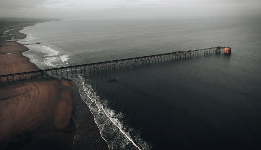
Chapter Four: The Durham Heritage Coast and Beach Detecting
Introduction to the Coastal Strip
The Durham Heritage Coast extends for approximately eleven miles along the eastern edge of the county, running from Seaham in the north to the Tees estuary in the south. This stretch of coastline is one of the most dramatically beautiful in North-East England — a landscape of limestone cliffs, hidden coves, and wide sandy beaches that has undergone a remarkable transformation in recent decades. Following the closure of the Durham coalfield’s coastal collieries in the 1980s and 1990s, an intensive programme of environmental restoration removed millions of tonnes of colliery spoil from the beaches and cliffs, restoring the natural character of the coast and revealing beaches that had been buried under industrial waste for over a century.
This restoration has been spectacularly successful, and the Durham Heritage Coast is now recognised as a nationally important landscape for both wildlife and recreation. For the metal detectorist, the reopening of these beaches has created exciting new opportunities — beaches that were inaccessible for generations are now open, and the removal of colliery spoil has in some cases exposed older sediments and beach surfaces that had been sealed beneath the industrial debris for many decades.
The coastal towns and villages of the Durham shoreline have their own rich histories. Seaham, in the north, was the birthplace of the poet Lord Byron’s marriage, the home of the Londonderry coal-shipping dynasty, and a major coal exporting port throughout the 19th century. Hartlepool, at the southern end of the coast, is one of the oldest settlements on the North-East coast, with a history of continuous occupation stretching back to the Anglo-Saxon period, when it was home to an important monastery. Between them, smaller communities such as Horden, Easington Colliery, Peterlee, and Blackhall Colliery all grew up around the coal industry, though their maritime surroundings are far older.
Specific Beach Locations
Seaham Beach is one of the most popular detecting locations on the Durham coast. The beach at Seaham is a wide, sandy bay backed by low cliffs, easily accessible from the town centre, and well known for two quite different categories of find. The first is sea glass — beautiful fragments of old glass bottles and vessels, tumbled and frosted by the sea, which collectors prize for their colours and history. While sea glass is not detectable in the conventional sense, the same beach conditions that produce good sea glass yields tend to produce good metal finds too, particularly in the areas immediately below the cliff face where older material is exposed.
The second and more specifically detecting-related attraction of Seaham is its historical association with shipping and the coal trade. Coins, tokens, and personal items lost or discarded by sailors and dock workers over centuries of maritime activity have been washing out of the cliff sediments and being reworked by the sea for decades. After storms, the beach at Seaham can yield surprising finds from a range of periods — including Victorian and Edwardian copper coins, lead cloth seals from the textile trade, and occasionally older material from the medieval and post-medieval periods.
Crimdon Beach at the southern end of the Heritage Coast is a wide sandy beach backed by dunes, with a caravan park to the north and open farmland to the south. The beach here is Crown Estate foreshore between the tide marks, making it freely detectable. Crimdon was a popular holiday destination in the early-to-mid 20th century, with a pleasure ground and charabanc trips from the mining towns bringing thousands of families to the seaside. This recreational use means that the dry sand and upper beach areas are likely to yield 20th century coins, jewellery, and personal items from the holiday-going crowds — exactly the kind of material that makes beach detecting so enjoyable and financially rewarding.
Blackhall Rocks is perhaps the most scenically dramatic location on the Durham Heritage Coast for the detectorist. The beach here is overlooked by towering magnesian limestone cliffs and is accessible via a steep path from the clifftop car park. The beach was heavily affected by colliery spoil for most of the 20th century, but the environmental restoration programme has cleared it dramatically, and the exposed limestone rock platforms at low tide reveal a landscape that was last accessible before the coal industry transformed this coastline. Wave action here can expose older sediments and archaeological material, particularly after winter storms.
Hartlepool Bay, at the southern end of the Durham coast, offers a quite different kind of beach detecting experience. The wide sandy beach backed by dunes has been a popular recreational destination for well over a century, and the volume of coins, jewellery, and personal items deposited here by generations of holidaymakers and day-trippers is substantial. The older parts of the bay, near the historic headland of Hartlepool, also carry the potential for finds from the town’s Anglo-Saxon and medieval heritage — a monastery founded in the 7th century on the headland has left archaeological traces throughout the area.
Tides, Conditions, and Equipment
Beach detecting on the Durham coast requires some specific preparation that differs from inland detecting. The most important consideration is the tide — you want to plan your detecting session so that you arrive as the tide is going out, allowing you to work the wet sand zone as it is exposed, and to follow the receding water’s edge as it retreats. The wet sand zone between the high and low water marks tends to be the most productive area on any beach, as the tidal action concentrates lighter objects and regularly reworks the sand to expose new material.
Weather and sea conditions matter enormously on this coastline. The North Sea can be rough and unpredictable, particularly in autumn and winter, and the wave action during storms is what drives the beach erosion that exposes older material. A week after a significant North Sea storm is often the best time to detect the Durham beaches, as the disturbed sand settles but the freshly exposed layers remain accessible before they are covered again. Always check the weather forecast and tide tables before setting out, and be aware that the limestone cliff faces at locations like Blackhall Rocks can be unstable — never detect beneath overhanging cliffs.
In terms of equipment, a detector with a waterproof coil is essential for wet sand work, and a detector with good performance in salt-mineralised ground is preferable for the intertidal zone. The Minelab Equinox series and the Garrett AT Pro are both popular choices among beach detectorists in the North-East for this reason. A stainless steel sand scoop is invaluable for digging in wet sand efficiently — a standard digging trowel is frustrating and time-consuming on the beach. Carry a finds pouch for your keepers and a separate bag for the inevitable rubbish, and always leave the beach exactly as you found it.
Viking Activity and Earlier Coastal History
It would be a mistake to think of the Durham coast purely in terms of the medieval and modern periods. The North-East coast of England was a zone of intense Viking activity during the 9th and 10th centuries, with Scandinavian raiders, traders, and settlers leaving their mark on the landscape and the language of the region. The place names of coastal County Durham reflect this Norse heritage — names ending in -by, -thorpe, and -ness all testify to a period of Scandinavian settlement that transformed the region.
Viking metalwork is among the most prized of all detecting finds, and while the majority of significant Viking hoards from the North-East have come from inland rather than coastal sites, the coastal zone was clearly an area of activity during the Viking Age. Hack silver — fragments of cut-up silver objects used as a form of currency before coinage became dominant — is the most characteristic Viking find type, and silver arm rings, ingots, and penannular brooches have all been recovered from Viking contexts in the broader North-East region. While such finds are genuinely rare, the possibility of a Viking connection is always present when detecting in areas with Norse place names or documented Scandinavian associations.
The Anglo-Saxon period that preceded the Vikings is also well represented in the Durham coastal zone. The monastery at Hartlepool was one of several important religious houses established on the North-East coast in the 7th and 8th centuries, and finds of Anglo-Saxon metalwork — including the distinctive animal-interlace decorated brooches, pins, and strap fittings of the period — have been made from sites across the region. The coast was also a zone of exchange and trade in this period, with goods moving by sea between communities on both sides of the North Sea, and the occasional Continental object turning up in English coastal contexts.
The Coal Heritage and Modern Finds
No account of metal detecting on the Durham coast would be complete without acknowledging the industrial heritage that so profoundly shaped this landscape. The collieries that drove coal down to the coast via staiths and ships from the 18th century onwards generated enormous quantities of industrial metalwork — machinery, fittings, tokens, tools, and the personal possessions of the men who worked in the most dangerous industry in England. While this material lacks the antiquity of Roman or medieval finds, it has its own historical interest and some of it — particularly colliery pay tokens, check discs, and the brass lamps used underground — is actively collected.
Victorian and Edwardian coinage is abundant on the Durham beaches, reflecting both the recreational use of the coast and the general circulation of coins throughout the mining communities of the hinterland. George IV, William IV, Victoria, Edward VII, and George V copper and silver coins turn up regularly, and the occasional florin, shilling, or even half-crown in good condition makes a satisfying find. Post-1947 coins — made of cupro-nickel rather than silver — are less exciting monetarily but can still be in good condition and are a useful indicator that you are working a productive area for more valuable finds nearby.
Jewellery is always the most sought-after category of beach find, and the Durham beaches deliver their share of rings, brooches, chains, and earrings from the 20th century recreational period. Gold is rare but not unknown — a lost wedding ring or signet ring in good condition is a genuinely life-enhancing find, and the beach detectorist who sticks at it through the less productive days will eventually be rewarded with something truly special.