Chapter One: Norfolk — England’s Treasure County
Norfolk sits on the eastern edge of England, jutting boldly into the North Sea like a clenched fist daring the tides to do their worst. It is a county of extraordinary contrasts — vast skies arching over flat, open farmland; ancient market towns drowsing beside reed-filled waterways; and a coastline that stretches for over 90 miles, much of it wild, windswept, and utterly untamed. For the metal detectorist, no county in England offers greater promise. In 2024, Norfolk recorded more treasure finds than any other county in England, with detectorists reporting a total of 138 treasure discoveries and over 7,120 artefacts — figures that leave every other county trailing far behind.
That extraordinary record is no accident. Norfolk has been at the centre of human activity for almost a million years. It was here, on the eroding cliffs of Happisburgh on the north-east coast, that archaeologists discovered 850,000-year-old human footprints — the oldest evidence of mankind ever found outside Africa. A flint handaxe recovered near the same village was found to be almost 200,000 years older than any previously known artefact in Britain, forcing a wholesale rewrite of the country’s prehistoric timeline. The ground beneath Norfolk’s fields and beaches has soaked up the presence of Neolithic farmers, Bronze Age traders, Iron Age tribes, Roman legions, Anglo-Saxon settlers, Viking raiders, Norman lords, and medieval merchants. Layer upon layer of history lies waiting just beneath the surface, and it is the job of the modern detectorist to bring it back into the light.
The Lay of the Land
Norfolk is England’s fourth-largest county, covering approximately 2,074 square miles. It is bordered to the north and east by the North Sea, to the south by Suffolk, and to the west by Lincolnshire and Cambridgeshire. The county town is Norwich, one of England’s best-preserved medieval cities, while the coast takes in a remarkable variety of landscapes — from the chalk cliffs and Blue Flag beaches of the north to the sandy resorts of Great Yarmouth in the east and the wild saltmarshes and mudflats of the Wash in the west.
Norfolk is also the driest county in the United Kingdom, receiving less rainfall than almost anywhere else in England. That fact alone makes it an appealing prospect for year-round detecting. While detectorists in the wetter west of England are often defeated by waterlogged fields and treacherous mud, Norfolk’s beaches and farmland remain relatively workable for much of the year. The county’s agricultural landscape — dominated by arable farming — also plays in the detectorist’s favour. Ploughed fields churn up artefacts with every passing season, and the network of footpaths, permitted farmland, and accessible foreshore gives the serious hunter enormous scope.
The coastline itself divides broadly into three sections. The north Norfolk coast, running from Hunstanton in the west to Cromer in the east, is arguably the most spectacular — a designated Area of Outstanding Natural Beauty, rich in archaeology and home to some of England’s finest beaches. The east Norfolk coast runs from Cromer south to Great Yarmouth, passing through a series of traditional seaside resorts and crumbling cliff faces that regularly expose prehistoric and medieval material. The west Norfolk coast, bordering the Wash, is a more remote and challenging environment of salt marshes, tidal creeks, and lonely shingle banks where Roman and Bronze Age finds have been made for generations.
A County Shaped by the Sea
Understanding Norfolk’s coastline means understanding erosion. The county is losing ground to the sea at a rate that would alarm a homeowner but delight an archaeologist. The cliffs at Happisburgh, for instance, have retreated by as much as 30 metres in a single year during storm events, constantly exposing new layers of ancient sediment. This ongoing erosion is both a tragedy and a treasure chest. Buildings, field systems, and artefacts that were buried for millennia are now washing out of the cliffs and onto the beach, where a sharp-eyed detectorist or beachcomber may be the first person to encounter them in hundreds — or hundreds of thousands — of years.
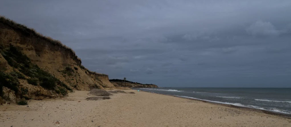
The same erosion that threatens the county’s cliffs also deposits material along the beaches in unpredictable patterns. After a significant storm, the configuration of a Norfolk beach can change entirely overnight. Sandbanks that have been building for years are stripped away, exposing the dark compacted layers below. Timbers from medieval and Bronze Age boats have been uncovered after storms at Holme-next-the-Sea, Brancaster, and Caister-on-Sea. Coins, buckles, musket balls, and medieval dress fittings have been found in freshly eroded cliff falls at Happisburgh, Mundesley, and Overstrand. For the detectorist who is willing to work the beach immediately after a storm, Norfolk can be extraordinarily generous.
Why Norfolk Tops the Treasure League
The question is sometimes asked: why does Norfolk consistently produce more treasure finds than any other English county? The answer is a combination of history, geology, and community. Historically, Norfolk was one of the wealthiest and most densely populated parts of medieval England. Norwich was the second city of England in the fourteenth century, and the county’s wool trade made it fabulously rich. That wealth circulated in the form of silver coins, gold rings, decorated brooches, and fine metalwork — all of which could be lost, hidden, or buried and subsequently forgotten.
Geologically, Norfolk’s light, sandy soils preserve metal well. Unlike the acidic clays of parts of the Midlands and the north, which can corrode iron and silver within decades, Norfolk’s alkaline soils maintain artefacts in a relatively stable state for centuries. A silver hammered coin buried in a Norfolk field in 1350 may emerge looking almost as bright as the day it was lost. This combination of historical density and geological preservation makes Norfolk uniquely rewarding for the detectorist.
The county is also home to one of England’s most active and well-organised detecting communities. Norfolk clubs and individual hunters work closely with the Norfolk Historic Environment Record and the Portable Antiquities Scheme, ensuring that finds are properly recorded and that the county’s extraordinary archaeological heritage is documented rather than simply pocketed. The result is a cumulative database of knowledge that makes Norfolk the best-understood detecting county in England — and a model for responsible practice everywhere else.
Chapter Two: The Best Beaches for the Detectorist
Norfolk’s coastline is 90 miles of opportunity, but not all of it is equally accessible or equally productive for the metal detectorist. Some beaches are protected by Natural England designations or owned by local authorities that operate blanket bans. Others are managed by the National Trust or the Crown Estate, where the rules are more nuanced. And some beaches — the ones that experienced hunters return to year after year — are simply outstanding in their combination of accessibility, history, and productive ground. This chapter covers the beaches that matter most.
Happisburgh — The Deep History Coast
If there is a single beach in Norfolk that deserves to be called sacred ground for the detectorist and the historian alike, it is Happisburgh (pronounced, in the baffling Norfolk manner, “Hazebruh”). This modest village on the north-east coast sits on the edge of the Deep History Coast, the 22-mile stretch of coastline between Weybourne and Cart Gap that has produced some of the most extraordinary prehistoric finds anywhere in the world.
The beach itself is accessible from the village car park and is particularly productive in winter and early spring, when storm erosion has done its work on the low clay cliffs. The cliffs here are composed of glacially deposited material laid down during the last Ice Age, and they contain flint artefacts, bone fragments, and organic material going back nearly a million years. The footprints discovered here in 2013 — made by a small group of early humans walking beside an ancient estuary — were so significant that they were hastily cast before the tide washed them away forever. They represent the oldest human footprints ever found outside Africa, and they were found on a Norfolk beach that any member of the public can visit on a quiet Tuesday morning.
For the metal detectorist, Happisburgh is interesting not only for its prehistoric potential but for its later history too. The village was a significant coastal settlement throughout the medieval period, and the beach regularly yields medieval dress accessories, coins, and fishing weights. Roman material occasionally appears as well, carried here by glacial action from sites further inland. After a storm, the beach between Happisburgh and Cart Gap is among the most productive searching grounds on the entire east coast. It was here, during a beach clean, that Jennie Fitzgerald found a locked chest containing approximately 100 coins ranging from Roman to Victorian, along with a signet ring, a silver matchstick holder, and an old pocket watch.
West Runton — Mammoth Territory
West Runton, on the north Norfolk coast between Sheringham and Cromer, is perhaps best known for the extraordinary find made in 1990 when local residents discovered the bones of a mammoth eroding from the base of the cliffs. The West Runton Mammoth, as it came to be known, proved to be the largest and most complete fossilised mammoth skeleton ever found in the United Kingdom, estimated to be around 600,000 years old. Excavation in 1995 recovered the majority of the skeleton, and it can now be seen at the Norwich Castle Museum.
The beach itself is a mixture of sand, chalk, and flint pebbles, and the cliffs behind it expose the same dark Cromer Forest Bed — a layer of ancient organic sediment — that produced the mammoth bones. Fossil hunters come here for echinoids, ammonites, and sea sponges, and after winter storms it is possible to find bone fragments and plant material from the Forest Bed lying on the beach. For the detectorist, the more productive ground lies in the area above the tide line, where the beach meets the base of the cliffs. Victorian and Edwardian beach visitors dropped coins and personal items here in considerable numbers, and earlier material occasionally appears after significant erosion events.
The chalk reef that runs offshore from West Runton towards Cromer is also worth noting. This is the world’s longest chalk reef, stretching for over 20 miles, and it is more than 100 million years old. The reef creates a sheltered inshore zone that historically supported a fishing industry, and the remains of that industry — anchor chains, lead weights, iron fittings from boats — lie scattered across the seabed and on the beaches to either side.
Holkham — The Crown Jewel
Holkham Beach, situated on the north Norfolk coast just west of Wells-next-the-Sea, is widely regarded as one of the finest beaches in England. It is a vast, sweeping expanse of pale sand backed by one of the largest sand dune systems in the country, with a pine forest planted in the nineteenth century providing a dramatic backdrop to the seaward view. The beach is reached via a twenty-minute walk through the pinewoods from the car park at Lady Anne’s Drive, and in summer it can feel genuinely remote despite being well-known to tourists.
Holkham is part of the Holkham National Nature Reserve, which means that metal detecting is subject to restrictions — the National Trust and Natural England both have interests in this stretch of coast, and written permission must be obtained before detecting here. However, the foreshore itself — the intertidal zone between high and low water — falls under the Crown Estate’s permissive right, meaning that detecting on the beach between the tide marks is generally permitted without a formal licence, subject to the Treasure Act and good detecting practice.
The productive potential of Holkham is significant. The nearby Holkham Hall estate has been at the centre of Norfolk life since the eighteenth century, and the estate’s history stretches back through the medieval period. The beach was used by fishing communities for centuries, and the dunes behind it have yielded finds ranging from Roman coins to medieval lead tokens. The remoteness of the beach also means that it receives relatively little attention from casual detectorists, which adds to its appeal for the more determined hunter.
Hunstanton — Striped Cliffs and Geological Treasure
Hunstanton, on the north-west tip of Norfolk where the county turns the corner to face west across the Wash, is unique among English resorts in facing west rather than east — which means it offers sunsets over the sea, an experience that feels almost un-English. More importantly for the detectorist, it sits beneath a set of remarkable layered cliffs composed of alternating bands of red chalk, white chalk, and brown carstone, which have been providing finds to hunters for generations.
The beach here is composed of flat chalk ledges exposed at low tide, giving way to sand further out. The chalk geology means that fossil hunters do well at Hunstanton, with bivalves, echinoids, and occasional shark teeth emerging from the cliff faces. The detectorist, meanwhile, benefits from the town’s long history as a Victorian seaside resort. Hunstanton was developed as a planned resort in the 1840s by Hamon le Strange, and the promenade and pier brought thousands of visitors — and their coins, rings, and personal effects — to the beach every summer season. Beach-combing and detecting around the old pier foundations, where erosion has disturbed Victorian material, can be particularly rewarding.
The wider Hunstanton area also has a significant Roman and Bronze Age history. The Wash coastline was heavily used by Roman traders, and the extensive salt marshes between Hunstanton and the Wash proper contain the remains of Roman salt-making installations. Bronze Age roundbarrows sit on the higher ground above the town, and Roman material has been recorded across the fields and beaches of the surrounding parishes.
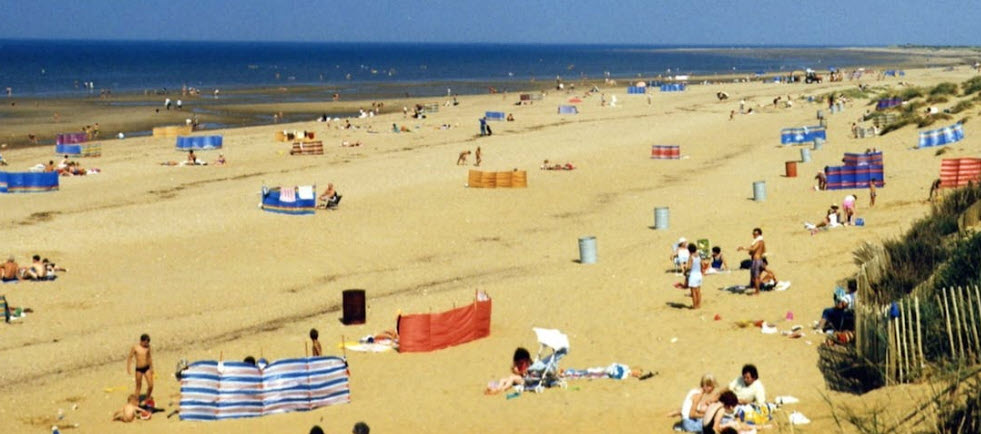
Great Yarmouth — Urban Treasure
Great Yarmouth, Norfolk’s major east-coast resort, offers a very different detecting environment from the remote marshes and empty dune beaches of the north coast. This is a busy, historic town with a beach that has been attracting visitors since the Victorian era, and the volume of lost material on and around the sands reflects that long human presence. The beach at Great Yarmouth stretches for several miles along the seafront and is publicly accessible. Detecting along the high tide line, particularly in the areas away from the most heavily trafficked sections, regularly produces coins, rings, and modern jewellery — as well as older material on occasion.
The town itself has a remarkable history. Great Yarmouth was one of the most important ports in medieval England, with a herring fair that attracted merchants from across northern Europe. The medieval town walls, stretches of which still stand, enclosed a densely packed settlement of merchants, fishermen, and traders. The beach immediately seaward of the old town has yielded medieval coins, lead tokens, and maritime fittings over the years, and the area around the old harbour mouth — now partially silted — is known to detectorists as productive ground.
The town also has connections to Lord Nelson, who landed at Great Yarmouth on his return from the Nile campaign in 1800 and was given a hero’s welcome. He is commemorated by a column that predates the more famous one in Trafalgar Square by several years. The combination of medieval history, Victorian resort development, and twentieth-century beach use makes Great Yarmouth one of the most consistently productive urban beaches in the county.
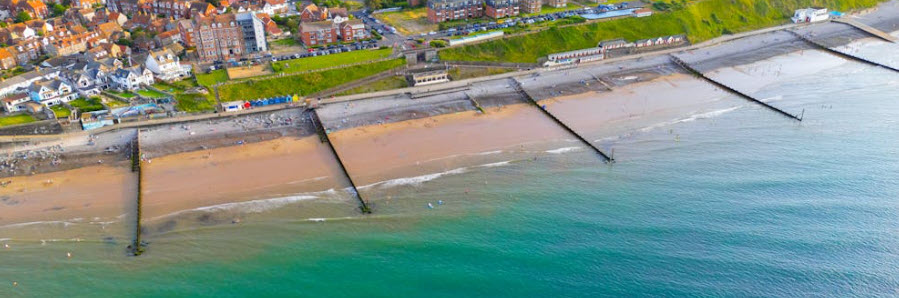
Cromer — The Pier Town
Cromer, perched on the north Norfolk coast between the chalk cliffs, is the kind of English seaside town that feels suspended in amber — a place of crab sandwiches, a proper Victorian pier, and an end-of-pier theatre that is the last of its kind in the world. The beach here is sandy and backed by low cliffs, and the town’s long history as both a fishing port and a resort means that the material culture buried in the sand is layered and varied.
Detecting at Cromer requires care. The beach is managed by North Norfolk District Council, and permission should be sought before detecting in areas above the high tide mark. However, the foreshore is accessible under the Crown Estate’s permissive arrangements, and the area around the old lifeboat station and the approaches to the pier is known to produce Victorian and Edwardian finds. The chalk reef offshore — part of the same geological formation as the White Cliffs of Dover — creates a sheltered zone around the pier that has historically been productive for divers and fishermen alike.
Cromer is also notable as a Blue Flag beach, along with East Runton, West Runton, Mundesley, Sea Palling, and Sheringham, meaning that the water quality and facilities here are among the best in England. That environmental quality reflects well on the condition of the beach itself — well-managed, clean, and with tidal patterns that regularly expose new ground at low water.
Chapter Three: Beach Conditions, Seasons, and Tactics
The Norfolk coast is not a static environment. It shifts and breathes with the seasons, responding to tidal surges, prevailing winds, and the long-term processes of erosion and deposition that have been reshaping this coastline for millennia. Understanding those rhythms — knowing when to go and where to stand — is the difference between a blank day and a day that fills the finds pouch.
Reading the Tides
Norfolk’s tidal range varies significantly along its length. On the north coast, the tidal range is relatively modest — typically between three and four metres at spring tides — which means that the width of foreshore exposed at low water can be considerable but not extreme. On the west coast bordering the Wash, however, the tidal range increases dramatically, and the sea retreats for miles at low spring tides, exposing vast stretches of sand and mudflat that are inaccessible at any other time.
The principle for all Norfolk beaches is the same: the most productive detecting is done at low water, when the tide has retreated far enough to expose ground that is rarely accessible. After a big spring tide — particularly one driven by an onshore wind — the surface layer of sand may have been stripped back to reveal the harder, older layers beneath. It is in those older layers that the best finds are made. A coin lost at Cromer in 1890 would have been worked down through the sand column by tidal action over the following decades, and it is only when an exceptional tide strips away the overburden that it becomes accessible to the detector coil.
The best tidal windows for beach detecting are generally the two hours before and two hours after low water. During this period the foreshore is exposed, the surface is workable, and there is time to cover productive ground before the sea returns. On the north Norfolk coast, the tidal tables at Wells-next-the-Sea and Blakeney are widely used by local detectorists as reference points.
Seasonal Strategy
Winter is the serious detectorist’s season on the Norfolk coast. The combination of equinoctial storms, powerful tidal surges, and the absence of summer beach users creates conditions that are uniquely productive. A northerly gale pushing water down through the North Sea can generate wave heights and tidal surges that strip metres of sand from a beach face in a single tide, exposing ground that has been sealed beneath the surface for years. The morning after such a storm, arriving at first light on an otherwise deserted beach, is one of the great experiences of the detecting calendar.
The north Norfolk coast is particularly susceptible to storm surge events. The tidal surge of 1953, which devastated communities along the east coast and killed 307 people in England, left visible marks on the Norfolk coastline that are still apparent today. Subsequent surges in 2013 and more recently have produced significant changes to beach profiles at Happisburgh, Walcott, Eccles, and Sea Palling. Each major surge event reshapes the beach and potentially brings new material within reach of the detector.
Summer, by contrast, is the season for tourist finds — modern coins, rings, earrings, and personal items lost by the thousands of visitors who flock to Norfolk’s beaches between June and September. This is perfectly valid detecting in its own right, and a beach like Great Yarmouth or Cromer on a summer evening — after the crowds have left but before the sea returns — can produce a remarkable quantity of modern silver and gold. The productive areas shift during summer, concentrating around beach cafes, ice cream stands, volleyball areas, and the approaches to car parks, where people routinely set down their bags and drop their valuables.
Autumn occupies a middle ground — the tourist season is ending, the first equinoctial storms are beginning to arrive, and the beaches are quieter than at any other time of year. This is an excellent window for exploring less-visited stretches of coast, building up knowledge of a beach’s topography before the serious winter erosion begins.
Ground Conditions and Equipment
The ground conditions on Norfolk beaches vary enormously depending on location and season. The sandy beaches of the north coast — Holkham, Brancaster, Wells — present relatively straightforward conditions for most detectors, with deep sandy profiles that require good depth penetration. A VLF detector running at 8–15 kHz will perform well in dry sand, but saltwater-saturated sand introduces the mineralisation problems that affect all VLF machines to some degree.
For the intertidal zone — the wet, salt-saturated sand exposed at low water — a pulse induction (PI) detector or a machine specifically designed for saltwater beach use will significantly outperform a standard VLF. The Minelab Equinox series, with its multi-frequency simultaneous (MF) technology, has become the machine of choice for many Norfolk beach detectorists precisely because it handles saltwater mineralisation well. The XP Deus 2 is another popular choice on the coast, offering excellent depth in difficult ground. For the chalk and flint beaches of the north coast cliffs, or the compacted shingle at Sheringham and Cromer, a standard detector will perform adequately, but coil size matters — a smaller DD coil will provide better separation in mineralised ground than a large mono coil.
The clay cliffs at Happisburgh and West Runton present specific challenges. Clay is highly mineralised, and detecting in or immediately below cliff falls can cause heavy false signals. Patience, slow sweeping, and careful ground balancing are essential. The finds that emerge from these cliff faces, however, are worth the extra effort.
Permissions and Rules
Before you detect on any Norfolk beach, you must understand the permissions landscape. The starting point is the Crown Estate’s permissive right, which allows metal detecting on Crown Estate foreshore — defined as the land between mean high and mean low water — without a formal licence, subject to the Treasure Act 1996. This permissive right is broadly applicable to most of Norfolk’s beaches, since the Crown Estate owns much of the English foreshore.
However, this right does not extend above the high water mark. Land above the high tide line may be owned by the local authority, the National Trust, Natural England, a private landowner, or a combination of these bodies, and each has its own policy on detecting. The Borough Council of King’s Lynn and West Norfolk, for example, does not permit metal detecting on the beaches it owns — which includes parts of Hunstanton and surrounding areas. Natural England has restrictions on detecting in SSSI (Site of Special Scientific Interest) areas, which cover large sections of the north Norfolk coast. The National Trust generally requires written permission and proof of insurance before granting access to its land.
The practical advice for Norfolk is to obtain a copy of the Ordnance Survey map for the beach you intend to detect, identify the ownership of the land above the high tide mark, and contact the relevant authority in advance. The Norfolk Metal Detecting Club maintains useful guidance on permissions for specific beaches, and the Portable Antiquities Scheme’s finds liaison officer for Norfolk can provide advice on particularly sensitive areas. All finds of potential significance must be reported under the Treasure Act, and good practice — filling holes, working carefully around other beach users — is essential.
Chapter Four: Remarkable Finds and the History Beneath the Sand
The history of metal detecting in Norfolk is a history of extraordinary finds — gold coins that rewrote the story of Roman Britain, Viking hoards that raised questions about the nature of early medieval trade, Bronze Age palstaves, Tudor dress rings, and Civil War musket balls, all emerging from the soil and sand of this most historically generous of English counties. This chapter tells some of those stories and sets them in the broader context of Norfolk’s remarkable past.
Prehistoric Norfolk — The Deep Time Finds
No account of detecting in Norfolk can ignore the prehistoric dimension. This is, after all, the county where the earliest Britons walked, where mammoths grazed the margins of an ancient estuary, and where the first recognisable human communities in northern Europe took shape. The finds from this period are not, for the most part, finds for the detector — flint tools, bone fragments, and ancient footprints are the province of the archaeologist and the trained eye rather than the metal detector coil. But they provide the essential backdrop against which the county’s later history unfolds.
The Deep History Coast between Weybourne and Cart Gap is where this prehistoric story is most visible. At Happisburgh 3, archaeologists have identified at least 80 flint artefacts and the footprints of a group of early humans, preserved in what were once estuarine sediments at the edge of a tidal river. The environmental evidence from this site — pollen, plant fragments, insect remains — paints a picture of a landscape very different from modern Norfolk: a conifer-dominated woodland bordering slow-moving tidal channels, inhabited by horses, mammoths, and rhinoceroses, and visited by small groups of hunter-gatherers who followed the game herds across the land bridge from continental Europe.
By the Bronze Age, Norfolk was already a sophisticated and well-connected society. Bronze Age traders moved along the Norfolk coast by boat, and the beaches and fields of the county have yielded a remarkable range of Bronze Age metalwork — palstaves, socketed axes, spearheads, and dress pins, many of them showing connections with workshops in Scandinavia, France, and Ireland. The Bronze Age boat excavated at Holme-next-the-Sea in 1998 — a timber circle arranged around a central inverted oak tree, its roots pointing skyward — was a reminder that the Norfolk coast has been a place of ritual and meaning since long before the Roman conquest.
The Roman Shore — Coins, Forts, and Salt
The Roman conquest of Britain in AD 43 transformed Norfolk from a territory of the Iceni tribe into a province of the Empire, and the physical evidence of that transformation is scattered across the county’s beaches and farmland in considerable quantity. Roman coins are among the most commonly reported finds in Norfolk, and the range of denominations and dates represented reflects the four centuries of Roman occupation.
The north Norfolk coast was of particular military and economic importance to the Romans. The fort at Brancaster — known in Roman records as Branodunum — was built in the AD 230s as part of the Saxon Shore system, a chain of coastal forts designed to deter sea-borne raiders from across the North Sea. The fort’s earthworks are still visible in the fields behind the beach, and the surrounding area regularly produces Roman military fittings, coins, and pottery. In 2012, Channel 4’s Time Team excavated five trenches across the site, discovering previously unknown granaries, barrack blocks, and a possible bathhouse — confirming that Branodunum was a substantial and well-appointed installation.
At Salthouse, on the north coast, the beach and surrounding saltmarsh are rich in the debris of Roman industry. Dark, bubbly pieces of iron slag — the by-product of charcoal-fired iron smelting — can be found near the beach, and the area was evidently a centre of metallurgical production during the Roman period. Roman salt production was also extensive along this coastline, and the remains of briquetage — the fired clay equipment used to produce and transport salt — has been recorded at numerous sites along the coast between Hunstanton and Brancaster.
Roman gold and silver finds from Norfolk have been among the most spectacular in England. The Snettisham Treasure, discovered in a series of finds between 1948 and 1990 in fields near Hunstanton, comprised more than 175 torcs, bracelets, and coin hoards — mostly of the Iceni tribe who inhabited Norfolk before the Roman conquest. While the main Snettisham finds were made by ploughing and excavation rather than detecting, subsequent metal detecting in the same area has added to the record, and the fields around Snettisham remain among the most closely watched detecting sites in England.
The Anglo-Saxon and Viking Age — Gold in the Sand
The period between the departure of the Roman legions in the early fifth century and the Norman Conquest of 1066 is richly represented in Norfolk’s detecting record. The Anglo-Saxon kingdoms that replaced Roman Britain in eastern England were sophisticated societies with a taste for elaborate metalwork, and the evidence of that taste turns up regularly in Norfolk’s fields and on its beaches.
Among the most extraordinary recent finds from Norfolk is an early medieval gold coin, altered to be worn as a pendant, discovered in 2024 and reported under the Treasure Act. The coin is a replica of one minted for Louis the Pious, the Frankish king and Holy Roman Emperor who ruled from AD 814 to 840, and it provides a remarkable window into the trading connections that linked ninth-century Norfolk with the Frankish Empire and, potentially, with Frisian and Viking merchants operating in the North Sea. The find raises fascinating questions about who was wearing such a pendant in Norfolk more than a thousand years ago, and why.
The Viking connection with Norfolk is strong and well-documented. Norfolk’s coastline was raided, settled, and traded with by Scandinavian seafarers from the late eighth century onwards, and the Danelaw — the zone of Viking political control — included Norfolk by the late ninth century. Viking silver hoards, hack-silver, and Scandinavian-style dress accessories have been recovered from Norfolk fields and beaches over many years, and the county’s place-names carry the Viking inheritance clearly: Happisburgh, Scratby, Hemsby, Ormesby — all ending in the Norse “by,” meaning a farmstead or village.
The hammered silver coins that turn up most frequently in Norfolk detecting sessions are medieval rather than Viking in date — English pennies, halfpennies, and farthings of the type struck from the Norman conquest onwards — but occasional Viking-age coins do appear, particularly in the north and east of the county. A Viking-age hoard found near Great Yarmouth in the 1980s included a mixture of English, Frankish, and Arabic coins — a snapshot of the international currency that circulated along the North Sea trade routes in the ninth and tenth centuries.
Medieval and Later — The Rich Centuries
The medieval period is the golden age of Norfolk detecting, in more senses than one. The county’s wealth in the fourteenth and fifteenth centuries, built on the wool and cloth trade, generated an enormous quantity of high-quality metalwork — gold and silver coins, decorated pilgrim badges, enamelled dress rings, heraldic pendants, and fine silver spoons — much of which has found its way into the soil and has been waiting for the detector ever since.
Norwich, the county’s medieval capital, was the second city of England by the fourteenth century, and its influence extended across the whole county through a network of markets, fairs, and trading relationships. The pilgrim routes that led to the famous shrine of Our Lady of Walsingham — one of the greatest shrines in medieval Europe, drawing pilgrims from across the continent — passed through numerous Norfolk towns and villages, scattering pilgrim badges and devotional objects along their length. Lead pilgrim badges depicting the Virgin of Walsingham have been found at beach and field sites across the county.
The coastal finds from the medieval period reflect Norfolk’s maritime economy. Lead net weights, bronze fishhook frames, iron anchors and their associated ironwork, and the coins and tokens lost by the merchants and fishermen who worked the coast appear regularly on the beaches around Great Yarmouth, Cromer, and Wells. The Norfolk coast was a significant centre of the herring fishing industry throughout the medieval period, and the remains of that industry are embedded in the sand and shingle of the beaches.
The post-medieval period — from the Tudor era through to the nineteenth century — adds another layer. Civil War musket balls and cavalry equipment appear in fields and on the beaches near towns that changed hands during the conflict. Eighteenth-century copper tokens — issued by merchants and businesses as small change during periods when the Royal Mint’s output was insufficient — are a common find. Victorian and Edwardian beach visitors, as already noted, contributed an enormous quantity of personal items to the sands. And the twentieth century has left its own archaeological footprint: the Norfolk coast is studded with the concrete remains of Second World War defences — pillboxes, anti-tank obstacles, gun emplacements, and the circular Whirlygig Cold War installation at Stiffkey — that represent a legitimate and increasingly valued part of the county’s historical record.
Notable Individual Finds — A Hall of Fame
To give a flavour of what Norfolk detecting can produce at its best, here is a selection of notable individual finds from the county’s beaches and foreshore:
The Happisburgh Treasure Chest (2022): Found during a beach clean between Cart Gap and Happisburgh, a locked wooden chest containing approximately 100 coins ranging from Roman to Victorian, plus a signet ring, engraved silver matchstick holder, pocket watch, and collection of gemstones.
Early Medieval Gold Pendant Coin (2024): A gold coin replica of a Louis the Pious piece, altered for use as a pendant, potentially connected to Frisian or Viking trade networks. Reported under the Treasure Act in Norfolk’s record-breaking 2024 treasure year.
Bronze Age Palstaves: Bronze axes and tools of the 1500–800 BC period have been found on beaches and farmland across Norfolk, particularly on the north and west coasts where Bronze Age trade routes ran close to shore.
Roman Military Fittings at Brancaster: Belt fittings, strap ends, and cavalry equipment consistent with the Roman garrison at Branodunum have been recovered from fields and the adjacent foreshore over many decades.
Viking Hack-Silver: Fragments of cut and tested silver — the everyday currency of the Viking trading world — have been found in north Norfolk, particularly in the parishes closest to the coast where Viking traders would have operated.
Medieval Pilgrim Badges: Lead pilgrim badges depicting the Virgin of Walsingham and other devotional subjects have appeared on detecting searches across the county, traces of the millions of medieval pilgrims who passed through Norfolk’s towns and villages on their way to the Shrine.
West Runton Mammoth (1990): Not a metal detect find, but the most famous coastal discovery in Norfolk’s history — the largest and most complete mammoth skeleton found in Britain, now displayed at Norwich Castle Museum. A reminder of what lies beneath the eroding cliffs of the Deep History Coast.
Final Notes for the Detectorist
Norfolk is a county that rewards patience, preparation, and respect. Its beaches give generously to those who approach them with knowledge of the tides, an understanding of the landscape’s history, and a commitment to recording and reporting what they find. The county leads England in treasure discoveries not because it is easy — it is not — but because its detectorists are serious, skilled, and engaged with the history they are uncovering.
For the visitor arriving for the first time, the north Norfolk coast between Hunstanton and Happisburgh is the obvious starting point: dramatic, historically rich, geologically fascinating, and accessible enough to reward a week’s concentrated effort. For the more experienced hunter, the quieter east and west coasts — the beaches around Caister, the saltmarsh fringes around Brancaster and Thornham, the tidal channels south of Hunstanton — offer deeper ground and more unusual finds for those prepared to do the research.
Carry your Crown Estate letter of authority, your Treasure Act reporting details, and your OS map. Fill your holes. Talk to the farmers and landowners whose land you work. And when you find something that matters — and in Norfolk, sooner or later, you will — report it, record it, and add it to the extraordinary cumulative story that this county’s detectorists have been building for generations.